Sunday, 25 September 2011

A Fell Run from Hartsop

19th September 2011

A Nice Run with a Stiff Start


I had been summoned by Andy Walmsley the Clayton Le Moors Harriers Z team captain to run a leg of the Ian Hodgson Fell Relay in the Lakes. My leg is from Hartsop to Patterdale and though I have done it before I thought a reccy of the route might be an idea.

Being a man of generosity who shares most things including pain with Keith I gave him a ring and asked if he fancied a jog in the Lakes. "Yes," I knew what the answer would be as I picked up the phone. The thought that it was forecast to be wet and cloudy which had been the norm anyway for days didn't matter as it makes for better running.

Being true Athletes we stopped at Dave and Pete"s butty van for our usual bacon teacake and brew. It is a welcome sight in the first lay by on the A590 Kendal Road off the M6. We are convinced that the lads bacon teacakes contain an energy giving ingredient as they have powered us up all the fells on our numerous walks without a trace of heartburn. The crack from the lads is worth the stop anyway.

Food Heaven


Appetites sated we drove over Kirkstone Pass in dramatic weather conditions. The road up from Troutbeck slipped in and out of cloud while on the fell sides white ribbons of cascading becks full from heavy rain split the green and grey slopes as they roared into the pass. Once over the summit as is usual in the Lakes the other side of the pass was dry and a bit brighter. Then again as is usual in the Lakes we knew it would rain sometime soon.

Kirkstone Pass into Patterdale

We parked the car at Hartsop NY408 131 and got into our running gear. It seemed a little bizarre as we were getting into shorts and vests a group of people from the next car were putting on heavy weather gear, macho or mad they were possibly thinking as they watched us.

Hartsop and the start of the run

The route starts on the track by the sheep fold with the brooding Gray Crag dominating the foreground. The track at first doesn't seem that steep and lulled us into setting off quicker than we intended. I was glad I had my camera and was contemplating this blog so stopped to take a photo of Pasture Beck. I don't think Keith objected too much as he pointed out the shot as grateful for the stop as I was.

Looking up Pasture Beck

However the short halt allowed us to get our breathing back in sync after our much too fast start and we felt pretty good when we set off again. That is until we got to Calfgate Gill NY 421130 which cuts into the near vertical fell side that rose on our left. There is always the though of "do we have to" when faced with a climb like this but the answer is always yes.

Keith on the climb

It is a really steep climb and soon became hands on thighs as we rose above the valley. Once into a climb like this the calf muscles really let you know they are not very happy and funnily enough your brain agrees with them at first but once your in a rhythm it becomes strangely enjoyable. Keith in particular loves these steep climbs as you gain height very quickly. I have to agree with him as some fells like Seat Allan go on forever without ever seeming to have a summit.

The top of the climb flattens into a boggy field that today became a muddy wade as opposed to a run but it wasn't too long before we reached the main path just below Buck Crag NY 421138. Here the route becomes excellent running terrain a really good path allowed us to stretch out and in no time we were descending to Angle Tarn NY 417 144.

Angle Tarn
I have never in my five visits been here when it has not been dull or raining and today wasn't going to change that sequence. It was dull but the rain held off but the same thing could not be said of Martindale away on our right.

Wet Martindale
The rain looked pretty torrential down in the valley. Mind it did look better than when Keith and I were on Place Fell in February and could see snow storms over Martindale.

Our path climbed a bit as it left Angle Tarn but we were in full flow and ran it all. We were now looking down into Patterdale on our left and behind us the cloud cleared giving views back to Brotherswater. Sometimes these type of days are better than a lovely sunny chocolate box views you get in summer as there is an air of drama in the atmosphere.

Keith with Brotherswater in the distance
Now we were going down hill to Boredale Hause a bit rocky and awkward to keep a regular pace but we enjoyed the ballet of dancing between the rocks and gullies to get good footing.

At Boredale Hause NY 407156 we were surprised to see the group of people we had seen getting ready to walk at the car. They had made pretty good time to get here. They must have come along the valley bottom from Hartsop and climbed the fairly steep ascent from just beyond Dubhow.

From here it is a really fast descent down the flank of the fell on a very steep and narrow path.

Path down to Side Farm


To me this is the essence of fell running as I love that feeling of just being on the edge as I run as fast as I can.
Flying Fell Runner.    Photo:Keith Butterworth


It can have repercussions as Keith was bombing down Helvellyn last year going flat out in the running section of a Triathlon and fell and broke his arm. Today however wasn't a race so we enjoyed a less nerve racking run down to the path junction at NY 400161 where we then picked up the main path to Side Farm NY 398162. A flat run across the valley floor brought us to Patterdale School NY 394160.

That basically was the race route done as it finishes just behind the church across the road in the sports field. Common sense would have now told us to retrace our route to Side Farm then take the lower path along the valley to Hartsop. This is the shortest way back to the car and the chicken sandwiches Barbara, Keith's wife and lovingly prepared for him but with one extra for me. Thanks Barbara it was good.

Common sense if you follow my blogs is not a thing that Keith and I seem to have a lot of. Yet again it failed to reach the parts of brain that instruct the body to use it. One of us said " How about going up Deepdale, then we could pick our way up to Gale Crag and drop down to the car park at Brotherswater on the other side of the fell." The other must have agreed as soon we were running along the main road avoiding getting drenched by passing cars going through puddles. Its strange how when these ideas come up neither of us can remember who first thought of it.

The path to Deepdale


We reached the track to Deepdale at NY398148 glad to feel gravel instead of tarmac under our feet. The upper reaches of Deepdale were shrouded in heavy cloud and certainly did not look inviting in running gear but of course that was not our intention. We figured out that if we ran to a point the walled fields gave way to open fell then crossed the river we could make our way up to Gale Crag. We found the point at NY 391133. The beauty of fell shoes is that unlike boots you don't need to take them off to wade rivers. Keith admirably shows this in the next photo.

The Wader

We crossed the river and ploughed through some boggy ground then picked up the dry stone wall which meandered its way up the fell to meet the stone dry stone wall that marks the ridge that climbs up to Hartsop above How. At the junction a ladder stile splits the wall we followed from the river. Before we got to it Keith reckoned we were too low and he was right we were well below Gale Crag. Another uphill beckoned and it started to rain but it was worth a quick jump over the stile to get the wet view back to Patterdale.

Looking back to Patterdale

Just under Gale Crag NY392124 another ladder stile crosses the ridge wall and once over this we looked  down into Hartsop.

Looking into Patterdale from Gale Crag
At least it was downhill all the way to the main road but what a downhill. It's a very narrow path that drops gradually as it contours the fell side. Muddy in parts and a bit slippery in the rain but runnable and we enjoyed the pace until at NY399133 it reaches the top of a wood. Here it drops like Blackpool's big one. It would be hard on the thighs on its own but we had already done a big descent on the opposite side of the valley. Even then we would have grinned and put up with it but the rain made the path slippery to say the least so screaming thighs were relegated in the brain to second place as avoiding breaking our necks took first.

We gladly reached the Brotherswater Car Park NY402133 which even on a rainy day was quite full. From here it was a gentle jog back to Hartsop and the car. We changed into dry clothes under the hatchback of the car then sat eating Barbara's chicken butties with the windscreen wipers going so we could see the fells. Mad or what..........I'll take the former.

Technical Bit


Sunday, 14 August 2011

A Lovely Day in Longsleddale

8th August 2011

A Relatively Moderate Walk with Magnificent Views.

Of course the weather forecast was grim when we left Blackburn but as Keith remarked that it never stopped us before. It had been a while since we had managed to get a walk together due to work and family commitments in my case and in Keith's a desire to emigrate to Scotland on the open road. In other words he spent a couple of months building a mobile home and a further month north of the border trying it out. However back and sounding like Rab C Nesbitt he treated me to a bacon butty at Dave and Pete's caravan situated in the first lay by on the A590 Kendal Road from the M6. When I was a very young cyclist the older riders used to swear bacon butties gave you energy. This maybe a myth but they certainly taste good before a day on the fell.


It was good to see the two lads again and as usual the food was excellent. The bacon cooked on a skillet    until crisp, the edges just slightly curling as Pete slid it into a soft fresh teacake. They said they had been wondering what had happened to us and of course I had to bring up the subject of my mate moving to Scotland. "Blame him," I said.

We had decided to go to Longsleddale to start our walk. Unusually for us we had decided this before we set off from home. Normally Dave and Pete's is our what shall we do centre. We pack the gear for all weather so anywhere in the Lakes is an option. Today full of anticipation and bacon we drove through the damp grey streets of Kendal and up the A6 towards Shap. At NY525 986 we turned off the A6 and took the narrow road to Longsleddale eventually reaching the hamlet of Sadgill where we parked. It must be noted there is not a lot of car parking space in Longsleddale.


                                                                           Sadgill

Today we were on our own ours was the only car. We wondered why as Longsleddale is a beautiful valley yet seemingly untouched by mass tourism. The weather looked as it may go one way or the other, it could rain, or it would rain. We were to be proved wrong but at that moment it was jacket or not. Not was the decision and we set off with our waterproofs in the rucksacks wearing tracker bottoms and light tops. This proved to be correct in less than 10 minutes we were dripping with sweat. Dull it may have been but it was still August and very humid.


Longsleddale

The bleating of sheep, birdsong and the crunch of boots on gravel coupled with the melodic sound of the River Sprint tumbling  along the valley floor were the only sounds. There was no breeze and the air hung heavy with the moisture of a light drizzle. Suddenly there was a commotion. A small bird had been targeted by a Sparrow Hawk and a dance of death or survival ensued. I thought it certain the hawk would catch its prey. The small bird however had different ideas and though seemed within millimetres of being clasped by the dagger talons of the hawk it managed to dodge left, right, up and down. Its size allowing it to turn in tighter circles than the much larger hawk. Eventually the hawk simply gave up and                                               
flew away.

It is good walking along the valley. The track is an old quarry road and is well made. On it's left hand side, early into the walk it passes under the seemingly menacing heights of Goats Scar that forms the south eastern flank of Kentmere Pike. By the standards of other crags in the Lakes it is not particularly massive but the fact that it rises directly from the valley floor gives it a presence of a true mountain.


Goat Scar

On the opposite side of the valley Buckbarrow Crag the southwestern flank of Tarn crag defiantly challenges Goat Scar as the dominant feature of Longsleddale. It is a well known to rock climbers with routes  of up to 100 metres vertically rising up its craggy face.

Buckbarrow Crag

Unfortunately for the climbers the crag was closed to climbing as Ravens were nesting. I once remember seeing a pair of Ravens in the Kentmere valley robbing the nest of a pair of Kestrels. A first I could only see one Raven and it kept flying close to the nest. One Kestrel was trying to drive the marauding attacker away and at one point it looked like it had succeeded as the Raven banked on the wind seemingly frightened by the fierce defence. It was a ruse as it simply drew the Kestrel further from the nest and when suddenly the Raven turned sharply it had positioned itself between the Kestrel and the nest. This caused the second Kestrel that had been sitting on the nest to join the defence and it flew to attack the Raven. In an instant a second Raven appeared from high on a crag and seconds later it had taken two chicks in its beak from the defenceless nest.

However I digress from our walk. We walked on up the valley and slowly the cloud began to break and shafts of sunlight began to flitter across the fells. It also began to burn the back of my neck and the sunburn cream I half heartedly shoved in my rucksack was gladly used. By now we were approaching the head of the valley and in the distance we could see the reason for the very good track. Wrengill Quarry. It was worth turning round and looking back down towards Sadgill. Because the walking is so easy we were surprised just how much distance we had covered.


Looking Back
Wrengill Quarry was famous in the early 1800's for the production of Blue Slate. The stream of Wren Gill that rises on the upper slopes of Harter Fell enters the quarry then disappears under ground into a series of sink holes and underground passages. Some may have been man made to ease flooding in the workings a problem shared with many Lakeland quarries and mines. It reappears as the River Sprint which in turn eventually becomes a tributary of the River Kent joining it just below the village of Burnside.

Falls on the River Sprint

Just past the start of the workings the path crosses a footbridge under which is a metal plaque engraved with the name. Denys Beddard 1917 - 1985.


Who Denys Beddard was or what his or maybe hers relationship to the area is anyones guess but some one or some group decided the person was worth what I would imagine a pretty costly plaque. Maybe one day Keith or I may get a plaque but given our group of mates it would probably say something not suitable for publication!!

At NY 474 092 Brownhowe Bottoms Longsleddale ends and the Gatesgarth Pass begins. Also at this point the path forks. The right forks leads down into Mosedale while the left leads over into Mardale Head and Haweswater. This was our path but our intention was not Mardale Head. A little further on at NY 474 093 between the the heights of Branstree on the right and Harter Fell on the left the path forks again. We bore left and began the climb up Harter Fell.

The Climb Up Harter Fell.   Photo: Keith Butterworth
 This is the hardest point of the walk steep in sections but not too difficult. It does however from the north east flank of Harter Fell open the panoramic view over Haweswater.


Haweswater from Harter Fell
I would think this is possibly the best view of Haweswater known to man. It was certainly different to when Keith and I were at Haweswater earlier in the year when in was cold a raining. The path follows a wire fence all the way to Harter Fell summit and as it starts to turn south west the view changes to overlook the two tarns of Small Water and Blea Water. We reminded each other of when we were last on the shores of these in white out winter conditions, now we were getting sunburned.

Small Water in the foreground with Blea Water behind
However this suddenly looked like it would change as we approached the summit of Harter Fell. We now looked over High Street the north western fells, the ones we could see that were not obliterated by a huge black rain clouds heading straight towards us on a now cold and strengthening wind.

"Bet we have our cags on by the time we reach the top." Keith said pessimistically.

I was more concerned in the fact that we were both hungry and there was no shelter at all. My ham, cheese and piccalilly sandwiches were only designed to get wet after I had swallowed them. There is a certain niceness in eating lunch in an old barn or under the shelter of a crag watching the clouds go by. There is no niceness eating on a bare open fell and looking at the approaching storm it began to look like lunch would be eaten back at the car.

Keith on Harter Fell Summit with Storm Clouds Coming
We watched as first Thornthwaite Crag then Ill Bell were eaten by the clag. Our turn next, though we had yet to even get the cags out of our rucksacks we accepted a drenching that never happened. The usual vagaries of Lakeland weather kicked in and the rain completely passed us by. It caught the summit of Kentmere Pike which was our next mountain to visit on the ridge south of Harter Fell and all the mountains to the west but not us.


Storm over Kentmere Pike
Amazing but very nice indeed and we simply dropped out of the wind and sat enjoying our lunch looking east over the Shap Fells with great views of the Sedbergh Hills  and Penrith and the Northern Pennines. We could plainly see the M6 where it splits into two levels as it climbs up to Shap and between us contemplated how many vehicles must pass along that point in a year. It must be millions and I must admit that both Keith and I had many times been one of them yet neither of us had noticed Harter Fell from it.

Fed and re-energized we started towards Kentmere Pike but instead of taking the direct path we dropped down towards the Kent valley and then contoured back up. It was simply to get the view down to Kentmere reservoir.

                            Me looking into Kentmere.        Photo: Keith Butterworth
I like Kentmere Pike. It was here over 30 years ago I ran my first Lakeland Fell race the Kentmere Horseshoe and I have forgotten how many times I have done it in training. It is still an event though now it goes in the opposite direction. It still starts in Kentmere Village but in those days the route was: Kentmere Pike, Nanbeild Pass, High Street, Froswick, Ill Bell, then behind Yoke and back into the village via the Garburn Pass. Now it is the other way round which I have never done but Keith has. I still maintain the original way was best. Strangely on the Ill Bell side of Kentmere the path is like the M6 while on the Kentmere side it hardly makes an impression.

Me on Kentmere Pike.  Photo Keith Butterworth.

As seen on the photo Keith took of me on Kentmere Pike the weather had somewhat changed. It was now fantastically clear and the sun was burning. The views were stunning in all directions. Our day did prove however that the old adage of Lakeland weather can change in an instant and when you are on the fells take the right gear.

The view down the Kent Valley
In this kind of weather it is pretty hard to get it wrong and we followed the main path down towards Kentmere Village until NY469 070 where a fork in the path splits left to go over to Shipman Knotts. I would imagine in the fell race many a runner has come this way in bad weather instead of going right down into Kentmere.

View from Shipman Knotts into Longsleddale
We could now plainly see our way back into Longsleddale although there is a bit of a steep descent down from Shipman Knotts NY472 060 it was really pleasant walking. There is a cart track that connects the two valleys of Longsleddale and Kentmere and we joined it at NY475 049. From here it was an easy stroll back into Sadgill.


Path back to Sadgill

When we arrived at the car a group of youngsters on the Duke of Edinburgh Award had just arrived and were preparing to wild camp by the River Sprint. Both ends of the age spectrum but both loving the environment. Another great day, thanks Keith.


Friday, 4 March 2011

A Long Walk around Haweswater

21st Feb 2011

It was an awful weather forecast for the Lake District but our usual optimism took us up the M6 to Junction 36  and Dave and Pete's bacon butty van in the first lay by on the A590 Kendal Road.

The way to start a day
The usual friendly welcome awaited us as did sausage and spam sandwiches and a brew. It certainly put the weather to shame which was intent on doing us no favours today. The wind howled around the van and we huddled as a group with some lorry drivers under the awning to shelter from the pouring rain. It did bring us closer to the griddle plate and that perfect smell that only bacon being cooked has.

We sat in the car enjoying our feast while being buffeted by the wind and rain that hammered incessantly on the roof and windows. It was certain to be a low level walk for today but where? The weather forecasts for Ambleside and Keswick both said heavy rain and strong winds and watching the traffic disappear into the curtain of gloom that was hiding the way to Kendal they were about right. Then for some unknown reason I thought of Haweswater. It must have been twenty years since I stood on the shores of that lake and Keith almost the same. So that was it, the die was cast and off through Kendal, up the A6 to Shap and then Haweswater.

When we arrived at a little car park near the Haweswater dam. NY 502155 there was a big change in weather conditions. There was very little wind and although overcast only a light drizzle fell. It seemed unbelievable as 15 minutes earlier as we approached Shap on the A6 it had been the exact opposite. We put on the wet gear for the walk anyway expecting the Shap weather to follow us sometime in the day.

We walked back down the road to Naddle Bridge NY510159 then took the path to the left which ran through the woods under the dam to the North side of the lake.

Naddle Bridge

We then followed the lake shore path. It wasn't the most spectacular path at first probably due to the low cloud that covered the tops of the fells.

Start of the walk

It was though very easy walking and the path was good. I did get the impression that this area of the Lakes is not as popular as central Lakeland. It probably gets a share of visitors from Penrith and Carlisle but I suspect that walking is predominantly the reason as there is little to tempt mass tourism. As we walked on the views began to get better. There was very little chance that we would see blue skies and our usual.

" It might get brighter later on."

Was unspoken and probably unthought. However it was still dry and the wind was hardly noticeable which after Place Fell and our soaking last week was quite acceptable.
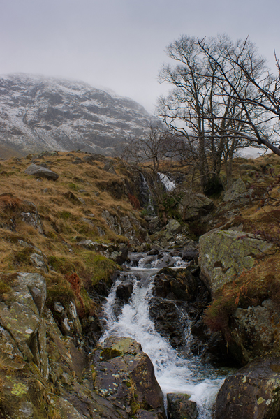
Whelter Beck

It was after the path climbed up under Whelter Knotts  NY472135 that the route began to look more dramatic. Ahead Castle Crag aptly named as on top sits the remains of an ancient hill fort and is the start of the more rocky ridges that climb towards the High Street plateau.

Approaching Castle Crag
The panorama of the upper end of Haweswater is completely different from the lower dam area. Here the lower rounded fells give way to true mountains although to be fair they didn't offer much in terms of spectacular vistas today. The lake began to narrow and soon we had a nice view of Speaking Crag NY 472121 and the Rigg NY 475116 two headlands extending into the lake. I have tried to find out how Speaking Crag got its name but cant seem to find any information. I suppose it may have something to do with the fact that the village of Mardale lies beneath the waters of the lake flooded when the dam was built in 1939. Considered one of the great feats of engineering when it was built the dam created a reservoir to supply water to Manchester. Sometimes in drought conditions the village reappears and the old walls can be seen  rising from the mud of the lake floor.

The path leads down to Speaking Crag

There was little chance of the village popping out of the water today as the next photo shows how high the lake level was.

High Water

It would be hard to imagine just where the end of this wall was in relation to the depth of the water but it looked a long way below the surface.

The view back from the Rigg to Speaking Crag


Once past the Rigg the end of the lake appears and above the bulk of Harter Fell dominates the scene.

Mardale Head the end of Haweswater

Here the waters of Mardale Beck flow into the lake fed from the high tarns of Blea Water and Small Water. Here we took the decision that at 2:45 pm it was a little too soon to head back down the far side of the lake to the car and it would be nice to go up to the tarns. "Nice" I don't remember who said the word but if it was me I claim a momentary lack of reason.


Mardale Beck and the path on the right

Up to Blea Water using the path on the right side of Mardale Beck, cross over to Small Water and come down the Path on the opposite side of Small Water Beck. That was the plan and in truth it was enjoyable except for a slight change in the weather.

Keith on the path to Blea Water
As seems to be a regular event given last week on Place Fell it began to snow. Of course this would not be complete without the wind getting stronger so cue strong wind. Oh yes, maybe thick cloud blotting out High Street would be an addition to the afternoon so cue thick cloud. Finally the crowds of walkers leaving hundreds of footprints in the snow that covered the now buried path that we could follow. Well maybe it had been one of those days when the shops in Ambleside or Keswick seemed better than a fell side as there wasn't even the footprint of a sheep never mind a walker.

A quick look at the Satmap told us we were  about a hundred feet below Blea Water that was up ahead in the mist. We simply stuck to the beck as it was pointless trying to find a path and soon the small dam at the mouth of Blea Water appeared.

A Glacial Looking Blea Water

The thick cloud was down to a few feet above the far side of the tarn and it gave an impression that we were looking at the edge of a glacier reaching the sea. The above photo is in colour but clearly shows the black and white view we had.

It is though a pretty interesting little tarn. For a start it is 530 metres 1987 feet above sea level. It derives it name from the Ancient Norse for dark blue, bley and is also the deepest tarn in the Lake District at 60 metres 197 feet deep. How you may ask could this be that such a small area of water has such a depth.

The picture below gives a simplistic description.

When the ice age finished the bowl filled with water

On a day like today it did not matter if it was 1 metre deep or 60 metres it certainly did not invite a swim. Keith however had to get a closer look and get at water level.

Keith looks for Blea Water Monster !!!

We took a bearing for Small Water the next glacially gouged tarn out of the flanks of the High Street massive. It was snowing pretty hard and of course the paths were buried under it and completely indistinct.

Leaving Blea Water

We trudged on through the snow and climbed over the hump that is the lower slopes of Piot Crag. Soon we were sliding down the opposite side and looking down at the dark surface of Small Water.


Down to Small Water


Keith decided to record the scene while blasted by snow

Small Water was formed in the same way as Blea Water but the similarity ends when comparing the depth. Small Water is about 9 metres deep and as the name suggests it is smaller in size. It made for a pretty wild scene as we reached the stepping stones at the point where Small Water Beck drains the water from the tarn and sends it tumbling to Haweswater. Keith tried his best to fall into the beck as he crossed the stepping stones.

Keith's Leap of Faith
It was my turn to have the camera but he managed to avoid the the fate I usually have when he photographs me in similar situations. He stayed dry.

Looking into Haweswater from Small Water Beck

Below us Haweswater slipped in and out of cloud cover and as we descended the path the snow gradually turned to rain. This began to ease and the bulk of Harter Fell NY459093 clawed its way from its cloudy cape into the brightening sky.

Harter Fell
There is evidence all around of the glaciers that formed these valleys but up to the right of us is what I consider one of the best examples. This is the huge glacial valley of Gatesgarth Pass NY 474092 that hangs between the heights of Harter Fell and Branstree NY 478099 and is about 300 metres above where we stood.

Gatesgarth Pass

If you consider the glacial ice reached almost to the summits of both Harter Fell and Branstree as it formed the valley then consider how much ice would have been above us on our little path. It seems hard to believe let alone quantify. Scientific evidence points to the fact that one day the ice will return to these valleys and peaks and that the earth at present is in a period between ice ages. I know however it wont be a problem to me as I think I will be long gone when it does happen.

The rain had stopped by the time we reached the car park at Mardale Head NY 469107. Only two cars  remained from the five I recall seeing from our earlier position on the opposite side of the lake. We had not seen a person since we set off to the tarns and all the way back down was a person free area. We were about to see less as one of the cars set off down the road.

Keith had seen on the map that there was a footpath that followed the lake shore. We reckoned it was about five miles back to the car and although getting late in the afternoon we could get back before dark following the path.

The view back to Mardale Head

It wasn't the best path though. It was narrow and obviously had not had a great deal of use. This was more evidence that this area is not the most visited in the Lakes. The path did give some very nice views as the day drifted into evening.

Evening Light over Harter Fell

We lost patience with the path after a while as it was slow going and looking ahead we realised there was every chance we would end up stumbling along in the dark before long.

The car is somewhere past the headland on the far right

We heard the last car on the car park go past along the road above us and decided that the better option was to take the tarmac route back. It was now pretty fast walking and I almost put the camera back in the rucksack, convinced that it would not be used again. As a photographers Keith and I are continually looking at the light. Its the bare canvas to paint a photograph and sometimes it can be infuriating. A full day can be spent chasing a photo but the light refuses to let you capture it. Other days the light is kind and provides a memory card of pleasure and you burst to get home and download it to the computer. Suddenly the light changed for one last hurrah before giving way to the encroaching darkness and picked out the distant High Street climbing from its prison of cloud. One shot and the camera was redundant for the day.

High Street and the last photo of the day

All that remained was a nice tramp along a beautifully almost quiet road. The atmosphere was still and the only sounds were of the distant falls on the far lake shore that we had passed hours ago, and the sound of thousands of what looked like small gulls that had taken a thin line in the centre of the lake to rest for the night. We must have walked for over a mile before we saw the end of this ribbon of life.

We passed the Haweswater Hotel Ny 483139 and to our surprise the car park was full. The smell of food cooking saturated the air and the thought of us sitting in a warm bar contemplating a pint of bitter flashed briefly across our imaginations. Oh well, cars and beer do not make happy partners so the millisecond of temptation passed easily. It was just 6:00 pm when we reached the car and it was dark but another great day done. Even the M6 was quiet on the way home, cant be bad.